Cyclonic Storm ‘VAYU’ over Eastcentral Arabian Sea: Cyclone Alert for Gujarat Coast
June 11, 2019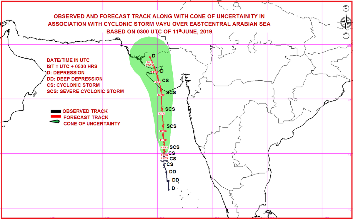
New Delhi: The Cyclonic Storm ‘VAYU’ (pronounced as VAA’YU) over Eastcentral Arabian Sea moved northwards with a speed of about 15 kmph in last six hours and lay centred at 0830 hrs IST of today, the 11th June, 2019 near latitude 15.0°N and longitude 70.6°E over Eastcentral Arabian Sea, about 350 km west-southwest of Goa, 510 km south-southwest of Mumbai (Maharashtra) and 650 km nearly south of Veraval (Gujarat). It is very likely to intensify further into a Severe Cyclonic Storm during next 12 hours.

It is very likely to move nearly northwards and cross Gujarat coast between Porbandar and Mahuva around Veraval & Diu region as a Severe Cyclonic Storm with wind speed 110-120 kmph gusting to 135 kmph during early morning of 13th June 2019.
Forecast track and intensity are given in the following table:
| Date/Time(IST) | Position (Lat. 0N/ long. 0E) | Maximum sustained surface wind speed (Kmph) | Category of cyclonic disturbance |
| 11.06.19/0830 | 15.0/70.6 | 70-80 gusting to 90 | Cyclonic Storm |
| 11.06.19/1130 | 15.3/70.6 | 80-90 gusting to 100 | Cyclonic Storm |
| 11.06.19/1730 | 16.0/70.6 | 90-100 gusting to 115 | Severe Cyclonic Storm |
| 11.06.19/2330 | 16.7/70.5 | 95-105 gusting to 120 | Severe Cyclonic Storm |
| 12.06.19/0530 | 17.5/70.5 | 100-110 gusting to 125 | Severe Cyclonic Storm |
| 12.06.19/1730 | 19.1/70.4 | 110-120 gusting to 135 | Severe Cyclonic Storm |
| 13.06.19/0530 | 20.8/70.3 | 110-120 gusting to 135 | Severe Cyclonic Storm |
| 13.06.19/1730 | 22.0/70.0 | 70-80 gusting to 90 | Cyclonic Storm |
| 14.06.19/0530 | 22.9/69.7 | 40-50 gusting to 60 | Depression |
| 14.06.19/1730 | 23.8/69.3 | 30-40 gusting to 50 | Depression |
Warnings:
(i) Heavy rainfall warning:
| Sub-Divisions | 11 June 2019* | 12 June 2019* | 13 June 2019* | 14 June 2019* |
| Konkan & Goa | Fairly widespread rainfall with heavy falls at isolated places | Widespread rainfall with heavy to very heavy falls at isolated places | Fairly widespread rainfall with heavy falls at isolated places | Fairly widespread rainfall |
| Saurashtra & Kutch | Rainfall at isolated places | Fairly widespread rainfall with heavy falls at isolated places | Widespread rainfall with heavy to very heavy falls at few places and extremely heavy falls at isolated places | Fairly widespread rainfall with heavy to very heavy falls at isolated places |
| South Gujarat Region | Rainfall at isolated places | Fairly widespread rainfall with heavy falls at isolated places | Rainfall at a few places with heavy falls at isolated places | Rainfall at a few places |
Note: * Rainfall till 0830 IST of next day.
Legends: Yellow: Be Updated; Orange- Be prepared; Red- Take action, Green: No warning
Heavy rain: 64.5-115.5 mm/day; Very heavy rain: 115.6-204.4 mm/day; Extremely heavy rain: more than 204.4 mm/day
(ii) Wind warning
- 11th June: Gale Wind speed reaching 70-80 kmph gusting to 90 kmph over Eastcentral Arabian Sea and 50-60 kmph gusting to 70 kmph along & off North Maharashtra coast by 11th evening. It is very likely to be 40-50 kmph gusting to 60 kmph over Lakshadweep area, Kerala, Karnataka & south Maharashtra Coasts.
- 12th June: Wind speed is very likely to increase further becoming gale wind speed reaching 110-120 kmph gusting to 135 kmph over eastcentral & adjoining northeast Arabian Sea by 12th night. It is very likely to be 60-70 kmph gusting to 80 kmph over Gujarat Coast from 12th morning and become gale wind speed reaching 110-120 kmph gusting to 135 kmph by 12th night. It is very likely to be 50-60 kmph gusting to 70 kmph over Maharashtra Coast.
- 13th June: Gale wind speed of the order of 110-120 kmph gusting to 135 kmph very likely over north Arabian Sea & Gujarat coast in morning hours and decrease gradually thereafter. It is very likely to be 50-60 kmph gusting to 70 kmph over north Maharashtra Coasts & northern parts of eastcentral Arabian Sea.
(iii) Sea condition
- The Sea condition is very likely to be high to very high over eastcentral Arabian Sea on 11th. The sea condition is very likely to become very high to phenomenal over eastcentral & adjoining northeast Arabian Sea & Gujarat coast from 12th evening and over north Arabian Sea on 13th June 2019.
- The sea condition is very likely to be rough over Lakshadweep area, along & off Kerala, Karnataka & south Maharashtra Coasts on 11th; rough to very rough along & off Maharashtra Coast on 12th; very rough to high along & off Gujarat, north Maharashtra Coasts & northern parts of eastcentral Arabian Sea on 13th June, 2019.
(iv) Fishermen Warning
- The fishermen are advised not to venture into Southeast Arabian Sea, Lakshadweep area, along & off Kerala and Karnataka coasts on 11th; Eastcentral Arabian Sea and along & off Maharashtra Coast on 11th & 12th; northeast Arabian sea and along & off Gujarat coast on 12th & 13th.
(iv) Storm Surge Warning
Storm surge of height of about 1.0- 1.5 m above the astronomical tides likely to inundate the low lying coastal areas of Kutch, Devbhoomi Dwarka, Porbandar, Junagarh, Diu, Gir Somnath, Amreli and Bhavnagar districts at the time of landfall.
(v) Damage Expected and Action suggested for Kutch, Devbhoomi Dwarka, Porbandar, Junagarh, Diu, Gir Somnath, Amreli and Bhavnagar districts of Gujarat:
(i) Major damage to thatched houses/ huts. Roof tops may blow off. Unattached metal sheets may fly. (ii) Minor damage to power and communication lines. (iii) Major damage to Kutcha and some damage to Pucca roads. Flooding of escape routes. (iv) Breaking of tree branches, uprooting of large avenue trees. Moderate damage to banana and papaya trees. Large dead limbs blown from trees. (v) Major damage to coastal crops. (vi) Damage to embankments/ salt pans.
Action suggested:
- Total suspension of fishing operations. (ii) Coastal hutment dwellers to be moved to safer places. People in affected areas to remain indoors. (iii) Movement in motor boats unsafe.

DeshGujarat
Related Stories
In constant touch with State govts, praying for safety and well being: PM Narendra Modi tweets
Vayu Cyclone updates
Recent Stories
- 12 Muslim candidates against Amit Shah in Gandhinagar Lok Sabha seat
- Nomination forms of Surat Lok Sabha seat Congress candidate, dummy candidate rejected
- Banas Dairy announces hike of Rs. 15 per kg fat of Milk
- Surat Congress candidate Nilesh Kumbhani's nomination form facing invalidation procedure
- ACB Gujarat decoy traps private hospital's staffer for bribery
- Chaitar Vasava has 13 FIRs against him under over 30 IPC sections in 3 police stations
- WR to run 2 pairs of Sabarmati-Barmer Special trains for summer